


Tōkyō Passenger Lines
There are a staggering number of rail lines around metropolitan Tōkyō. Even omitting subways, light rail (tram) and freight-only lines the map of the city is still a mesh of intersecting and parallel railway lines. And almost all of those are double-track routes dedicated to use by one of a couple of the routes. In some places as many as ten tracks (five double-tracked lines) run parallel to each other.
For additional info about non-passenger use, see my pages on Tōkyō Freight Lines and Non-Freight Lines.
Note: this map isn’t complete yet, and additional updates are planned. In particular at present it does not show any non-JR East lines, and there are several important ones, nor does it show Shinkansen lines.
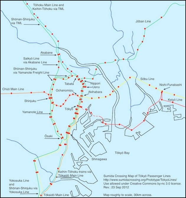
Major JR East Passenger Railway Lines of Metropolitan Tōkyō
The above map mixes physical railway lines and use of one physical set of tracks by two “lines” (routes). Dashed lines show underground sections of the lines (true “subway” lines are not shown). Blue lines are rivers, black lines show the coast of Tōkyō Bay and its major inlets. The map is roughly to scale and about 30 km side-to-side. Only major JR East lines are shown, no subway, light rail, freight-only or third-party railway lines are depicted, and some smaller JR East lines are omitted for clarity.
Railway Lines Around Tōkyō
All lines mentioned are electrified with 1500 Volt DC power from overhead catenary unless otherwise noted.
Chūō (Rapid) Line - Train Marking: Orange. The Chūō Main Line west of the city becomes the Chūō Rapid Line east of Shinjuku station and runs parallel to a separate set of Chūō-Sōbu tracks to Ochanomizu station, where it turns south into Kanda and then Tōkyō stations. West of Shinjuku the line is still used extensively for freight, but east of there freight is no longer permitted, in part due to an accident at Shijuku station in 1967 (see the Freight Lines page entries for the Chūō Line and Yamanote Freight Line for more on that).
Chūō-Sōbu Line - Train Marking: Yellow. The Chūō-Sōbu Line is a composite of the Sōbu Line east of the city-center and the non-Rapid portion of the Chūō line to the west (this portion extends 24 km to Mitaka station). For much of this length it has its own pair of tracks paralleling the other lines. The Sōbu Line itself extends from Tōkyō Station to the east 39 km to Chiba station in Chiba prefecture. The outer portion of the Sōbu Line is also used by trains running into the Tōkyō Metro Tōzai line, the connection to which is at Nishi-Funabashi, 30 km from Tōkyō.
Jōban Line - The Jōban Line is one of Tōkyō’s larger lines, running 343 km from Nippori station on the north side of Tokyo to the Northern city of Iwanuma (per wikipedia, most trains operate to Ueno just north of the city center over the parallel Tōhoku Main Line; possibly some also extend to Sendai over an outer section of that same line). And from just outside the city to Toride, the line is quadruple tracked (likely to support local commuters in addition to distant Rapid and inter-city services). However, beyond Toride (37 km from Nippori) the line is electrified with AC power, so outer-suburban trains must be dual-voltage models (such as the E531), single-voltage trains such as the E231 and E233 can only operate on the inner section. At Iwanuma it joins the Tōhoku Main Line.
Keihin-Tōhoku Line - Train Marking: TBD. The Keihin-Tōhoku Line is largely a virtual line (it has some dedicated trackage on the north side of the city), operating over the tracks of the Tōhoku Main Line and Tōkaidō Main Line, from Ōmiya 30 km north of Tōkyō Station to Yokohama 29 km south of it.
Keiyō Line - Train Marking: Cherry Red. The Keiyō Line runs along Tōkyō’s waterfront east of Tōkyō Station (which it reaches via an underground section). The physical line is shared with trains of the Musashino Line (which operates Rapid service from further out) as far east as Nishi-Funabashi (where the Keiyō and Sōbu lines meet).
Saikyō Line - The Saikyō Line (on map see the Shōnan-Shinjuku Line) largely parallels the Shōnan-Shinjuku Line from Ōmiya in the north to Ōsaki station at the southernmost point on the Yamanote line. However it stops at additional stations along the line (not all shown on map). It does not continue beyond Ōsaki. Between Akabane and Ikebukuro it diverges from the route followed by the Shōnan-Shinjuku Line to use the Akabane Line (which tracks are often incorrectly called the Saikyō Line).
Shōnan-Shinjuku Line - The Shōnan-Shinjuku Line is a virtual line for Rapid service using the tracks of several other lines, operating from Ōmiya 27 km north of Shinjuku, via Ikebukuro, Shinjuku, and Ōsaki Stations, to Ōfuna Station 53 km south of Shinjuku. According to one map, the portion from Akabane to Ikebukuro (which has no stops) isn’t routed the same way as the Saikyō Line, but instead curves east to pick up the Yamanote Freight Line tracks just west of Tabata station.
Sōbu Line - Train Marking: Yellow. See Chūō-Sōbu entry.
Tōhoku Main Line - The Tōhoku Main Line is the main railway line from Tōkyō to the northern end of Japan’s main island (ending at Morioka 535 km from Tōkyō). Although somewhat parallel to the Jōban Line, it runs more inland and further. Technically there is no single Tōhoku Main Line; it is composed of the Utsunomiya Line for the first 163 km to Kuroiso, the Southern Tōhoku Main Line for the next 189 km and the Central Tōhoku Main Line for the remainder. North of Kuroiso the line is AC-powered. At Iwanuma, 334 km from Tōkyō the Jōban line joins it (having taken about 10km further to get there).
Tōkaidō Main Line - The Tōkaidō Main Line is the main line heading west from Tōkyō, following a more level coastal route than the inland Chūō Main Line. It runs 446 km to Maibara in Shiga prefecture. The first 104 km (to Atami) are controlled by JR East, beyond that JR Central takes over until Maibara at 446 km, where JR West takes control for the remaining distance to Kōbe at 714 km.
Yamanote Line - Train Marking: Green. The Yamanote Line is Tōkyō’s inner beltway passenger line. Frequent trains orbit its 35 km length once an hour, stopping at all 29 stations in both directions and making a loop in as little as 59 minutes. At peak periods there can be as little as two and a half minutes between successive trains going the same direction. Top speed on the line is limited to 90 kph.
Yamanote Freight Line - Despite the name, these physical tracks largely paralleling the Yamanote line from Shinagawa Station in the south to where they diverge to Oji just south of Tabata Station are used by a number of passenger lines. There is no Yamanote Freight Line passenger service separate from that.
Yokosuka Line - Train Marking: blue/cream lines. The Yokosuka Line runs south from Tōkyō Station 73 km to Kurihama station. Some trains on this line run through onto the Sōbu Line east of the city.
Railway Yards
Passenger trains are largely stabled away from the city when not in use. There are also some smaller yards that can hold a few trains for the start of the morning rush (see note below). But for more extensive maintenance, JR East operates several passenger train facilities and locomotive depots (for loco-hauled inter-city trains) around the city. There are also a pair of Shinkansen depots.
North Side: There is a major passenger train service center (the Oku Vehicle Center, see Japanese Wikipedia) and a locomotive servicing center (Tabata Engine Depot) adjacent to Tabata station on the north side of the city. A Shinkansen yard is adjacent to both of these, but it’s unclear (to me anyway) if it is part of the Oku Vehicle Center or a separate facility.
South Side: Shinagawa Locomotive Depot is adjacent to Shinagawa Station, just south of Tōkyō Station. Tamachi Vehicle Center is associated and located with the Shinagawa Depot, and services passenger trains operating on the south side of Tokyo. A cryptic note on the Japanese wikipedia page for the Oku Vehicle Center suggests that Shiagawa is closing in 2013, with trains being transferred to Oku. There is a separate Shinkansen facility nearby on an artificial island on the waterfront, adjacent to the Oi District Authority freight center, but it is unclear if this is operated by JR East or JR Central.
Note: the sidings used for overnight storage of trains outside of a larger yard are known as denryūsen (電留線, “fraction line electric”) or ryūchisen (留置線,, “detention” or “placement line”) per a post on the JNS Forum, although the distinction isn’t clear. The Japanese WIkipedia entry for Rail Yard defines both terms with one paragraph referring to overnight storage as distinct from a service facility (I think, as usual the machine translation isn’t clear).
Other Maps
There are numerous other maps available online. The ones listed below are hardly a complete list, but may prove useful as a starting point. Although my map was created from route information on wikipedia and a physical map of metropolitan Tōkyō, some of these were used to confirm I hadn’t gotten myself confused.
Wikimedia Commons Yamanote Line Map
