


Scene Planning - Chūō Along the Kanda
My next layout is still very much in the back-of-a-napkin planning stage. I’m thinking about what goes into it more than the details of how I realize that. I have several things I know I want: multi-track urban commuter railroading, “layered” scenery with water, roads and railroads crossing each other at different levels, and prototype scenes from the core of Tōkyō. But just exactly what that means hasn’t fully come together yet.
One thing I do know that I want is a riverside scene or scenes along the Kanda river. This is a small river, running east to west and ending at its intersection with the much larger Sumida river in the center of the city. Near the eastern end it passes just south of the famous Akihabara district. A four-track mainline runs west along its south bank for a mile or so (about 2 km) before turning southwest along a different waterway and ultimately disappearing into a tunnel and turning north into Shinjuku station.
The railway along these two waterways lies in the center of Tōkyō, between the eastern and wester sides of the Yamanote line loop, which passes through Tōkyō station on the eastern end and Shinjuku station on the western end, and it serves as a shortcut across the middle of that line. Originally this was part of the Kōbu Railway, built in the late 1890’s, although portions were completed shortly after nationalization of the railways occurred in 1906. This can be seen in the largely wooden construction of the stations, with complex riveted girderwork in places.
Today the four-track route is divided into two tracks each for JR East’s Chūō Rapid and Chūō-Sōbu Lines. The former is an express line with few stops, the latter a local line. The Rapid line tracks are also sometimes referred to as a portion of the Chūō Main Line.
The name Chūō simply means “central”. Chūō Ward is one of the former Tōkyō’s 23 sub-cities; there is no individual city of Tōkyō today, although the name is retained for both the Prefecture and the Metropolitan Area that actually extends beyond it. Although it’s located largely south-east of Tōkyō station the ward is essentially the endpoint of the Chūō line. But the Chūō Main Line also runs through the center of the country, and likely takes its name from that. Just north of Shinjuku the line turns west serving the suburbs for commuters, with long-distance trains running all the way, as the Chūō Main Line, to Nagoya, several hundred miles/kilometers away.
At the east end, the line splits in two, with the Chūō Rapid line tracks curving to the southeast and terminating at Tōkyō station, while the Chūō-Sōbu tracks cross the Kanda river heading northeast, passing through Akihabara station before crossing the Sumida River into Koto Ward, and eventually leaving the city to serve the northeastern suburbs.
Along the Kanda lie a number of scenic features I’d like to incorporate. There’s a linear park of Sakura (Cherry) trees along one section, a small maintenance depot, a subway crossing the river to run under Ochanomizu station, and the station itself, which starts out as four parallel tracks on a level and ends with two climbing over a third to diverge. The backdrop is urban, with multi-story buildings, although close in these are smaller ones rather than the towers of the commercial areas. There are also multiple temples and shrines, although these are mostly on the north bank, which I don’t expect to model.
In terms of trains, the line is somewhat limited. It’s mostly used by the orange-stripe Chūō and yellow-stripe Sōbu (as the Chūō-Sōbu) trains. Charter (Joyful) trains could potentially use it, although I’d expect most to be routed further west along the Yamanote Freight Line tracks. I’m not aware of any other trains using it, which is partly why these tracks can only be a portion of a larger model railroad, at least for me.
My current thinking is that I’ll model a stretch of the south bank of the Kanda, with water in the foreground and the land with buildings rising behind that. At the left (east) end I’d have the river curve into the scenery so that tracks can cross it toward Akihabara. This will likely take the shape of a Y, with the two sets of tracks disappearing through backdrops to other scenes. I’m not sure that I’d model either Akihabara or Tōkyō station itself. Both are interesting, but don’t appeal to me as strongly as some other potential scenes.
The track itself is the real star though. It’s not straight, or even level. There are multiple curves as it follows the river, and surprisingly several elevation changes. At the east end, one track dives under others in two different places, and at the far west end the Rapid line dives under the Chūō-Sōbu to swap sides. And, as you can see in the diagram at the top of the post, there’s one half-km stretch with two double crossovers (just like the Kato track piece), one single crossover, and at least ten signal masts (I suspect two more exist that I haven’t been able to find on photos). There’s actually a third double-crossing just west of this, and a couple more signals.
It’s also signaled for bi-directional running, at least in places (at the east end all four tracks, and perhaps to the west only the Rapid line). This is a rarity in Japanese urban commuter lines, as they’re usually quite strict about keeping directions separate. That’s primarily an efficiency move, although safety probably plays a role as well. Bi-directional running implies more switches and signals, and anything that can break and snarl up rush-hour traffic is frowned upon.
I suspect the motivation for violating that here is simple volume. There isn’t room to add more tracks unless they build over the river, and apparently they aren’t quite that desperate yet. But the Chūō is, per one set of numbers I saw a few years back, Tōkyō’s busiest line, moving over 90,000 people per hour at peak time.
There’s also a need to connect the two sets of tracks at the east end. Along most of this stretch the Chūō Rapid line runs along the south side, and bypasses most stations, while the Chūō-Sōbu tracks are the two northern ones, with stops at all stations. But at the east end, these split with Chūō-Sōbu going to Akihabara and points west, while the Rapid line heads to Tōkyō station. Presumably some local trains need to go to Tōkyō, particularly at off-peak times, so they’d have to have some crossovers anyway. But they did it in a rather complicated fashion, so that the eastbound tracks of both lines could be adjacent with a platform between them (and similarly the westbound) to allow people who came in on one line to switch to the other to continue their journey.
I’ve been spending a lot of time looking at online images of this section of railway, notably via Google Earth and Google Maps, including use of Streetview where roads run close to tracks, although I’ve also used Wikipedia and Flickr as sources. I’ve been doing this so that I could identify where there were switches and sidings, and what signals were in use. Unfortunately in most places trees, buildings and grade separations make images of the track difficult, and so there are some gaps in what I’ve been able to identify. And even when I can identify how many lights a head has, usually they’re either dark or lit with one color (often green), which isn’t enough to identify clearly which kind of head is in use.
For example, 4-light heads are common on this stretch, but there are two versions of this, one optimized for higher speeds and one for lower. In places I’ve identified signals as type 4A or 4B due to the positioning of lights seen in photos, so both of these are in use and unidentified signals could be either. Some signals, particularly away from crossovers or stations, are of the simpler three-lamp design. I’ve even found one 5-lamp signal. So if I can’t see a signal well enough to count lamps, it could be anything. And if I can count lamps, unless it has three, there is still uncertainty.
Adding to my problems, some signals are hidden under bridges and inside stations, and apparently aren’t often photographed despite a fairly large number of station platform photos being online. I’ve found a few of these, but I’m pretty sure I’m missing some.
At least three of the stations have mid-platform signals, allowing two trains to park in the station and allowing trains to run through at speed if the platform isn’t occupied by another train. None of the stations have more than one track per direction for a line, eliminating most of the potential switches and signaling complexity.
The Signals
The signals themselves are fascinating, and important to understanding how the track works operationally. See my Signal Aspects page for more detail on signal aspects and their meaning.
In Japanese signaling, a “head” can have anything from two to six lights stacked vertically, although three or four are the most common form. When there is a branching, either two (or more) heads will be placed parallel to each other on the same mast (usually with one lower to signal the diverging route) or some kind of subordinate marker lights or other indicators will be used to show which route the head is currently showing.
Signals along this track reveal some interesting operational aspects. For example, the complex trackwork just west of Ochanomizu is clearly signaled for bi-directional use on all four tracks, and the two Rapid line tracks are signaled for bi-directional use further west as well. As mentioned above, that’s not typical of Japanese signaling practice. Oddly, while I thought the Chūō-Sōbu tracks were not signaled bi-directional, there’s clearly a wrong-way signal out by Sotobori Park, and since there are no crossovers closer to it than Ochanomizu, the whole line must permit wrong-way running. It seems oddly lacking in wrong-way signals though, but perhaps I just didn’t spot the others.
East of Ochanomizu is more traditional, but the complex of curves and a tunnel there shows how repeaters are used to provide advance notice of signals that are close but potentially out of site. A repeater shows the same indication as the next signal, but uses a distinctive form so it won’t be mistaken for a signal in its own right. A repeater showing “Stop” doesn’t mean “Stop here” it means “Stop at the next signal, which is very close”.
Just west of Ochanomizu are the crossovers, which need route-specific signaling, and interestingly the marker-light version appears to be used for wrong-way running, while the two-head version is used for the normal direction. This distinction only applies to crossovers, and further west where there are none there’s no apparent difference between normal and wrong-way signals.
In a normal railroad, a “short” block length is about 1.5 km (a mile). Several of the Chūō-Sōbu stations are half that distance apart, so it’s not surprising that there aren’t any block signals between them. In essence, the departure signal at a station is also a block signal. This can be seen clearly in one platform signal on the westbound line at IIdabashi Station, which bears a number plate (numbered “24”). Plates typically are present only on block signals, as distinct from “controlled” station signals. Station entry (“home”) and mid-platform signals are always controlled by the local stationmaster, so these would not have plates (and none I’ve found did).
It’s not consistent though. I’ve found signals outside stations without number plates, and others with them. I’m still trying to fully grasp what’s going on.
What I found interesting though was that for the most part, the Rapid line was signaled with three-lamp heads, rather than a specialized form that would allow for higher speed operation in congested areas. But the blocks here are very short, often just over the length of one train; as close as 250 meters in some places. I think what I’m seeing is a consequence of the fact that freight isn’t allowed on this line, coupled with the very effective braking of a modern EMU.
The E231 series trains used on this route can brake at 4.0 km/h/s (that’s normal, not emergency braking). The newer E233 can brake somewhat better. Even using the E231, and assuming a track speed of 60 km/h (which I’ve seen posted in a few places) that yields a stopping distance from full speed of just 125m, or half a typical block length. This means that as long as track speeds aren’t too high, closely-spaced signals don’t need extra aspects; just keep one empty block between trains (space trains at 750m spacing including the train length) and they’ll always get a green and be running at full speed. That’s less than a minute between trains, and typical headways are going to be several minutes, so I can see how this works.
The local line is signaled somewhat differently. Many of the signals are type 4A, which adds a Restricted Speed aspect, used when trains are running very close together or entering an occupied station (I expect the latter is their normal purpose). But others are type 4B, which lacks a Restricted indication, but allows two “faster than slow but slower than full” indications. I expect this is used to get trains away from stations as quickly as possible, and for the most part these are found departing stations.
The one five-aspect signal (a 5A) is on the Rapid line approaching Ochanomizu heading west. This type of signal allows all the aspects possible with either 4A or 4B, so I suspect the reason for it is that some Rapid trains run through the station at speed (and need the higher-speed aspects due to possible speed restrictions just west of the station at the crossovers, while others will need the Restricted aspect due to a train still in the station.
So even though I haven’t identified all of the signals, I have a good enough understanding of what they’re used for that I can model this track and assign types to the unknown signals. I might miss some subtlety doing that, but I’ll be consistent, and that’s more than good enough for a model.
As an aside, Tomix make models of all of the types of signals on this line except for the repeaters, for which you could use a single-head PRR position-light signal. I’ll probably end up scratch-building my own four-head and five-head signals, because the Tomix models aren’t all that good looking, and would take a lot of work to convert to external control.
Taking a Tour
Let’s take a walk along the route, as I know it today. I certainly won’t model all of this; if I did it would be massively compressed as the original would require more than 20 m (60’) in Japanese N-scale. Even selecting interesting scenes, a lot of compression will be required. Note: not all bridges are shown in my diagrams, I’ve only shown overpasses where signals may be hiding.
Ochanomizu and the Eastern Kanda
We’ll start at the east end, where the Chūō-Sōbu line arrives from the northeast, just after leaving Akihabara, and the Chūō Rapid line arrives from the southeast, having just left Kanda station, the first after the terminus at Tōkyō station. Both are busy double-track narrow-gauge commuter lines. Today they are passenger-only, although freight was carried in the past, and a portion of the Rapid line west of here carried some limited freight up until sometime in the 1990’s (I think; I don’t have an exact date). At this point, both lines are elevated above street level, but not by a lot; just enough to allow 3.9m to 4.1m (12.8 to 13.5 feet) of clearance for vehicles underneath.
The Rapid line crosses the roof of what used to be the Transportation Museum (and before 1943, Manseibashi Station; you can still see traces of the old platforms, although most of the station facade was destroyed in the Great Kantō Earthquake of 1923). Today this has a couple of small sidings, apparently used for maintenance equipment and the building below has been redeveloped into an “office and retail complex”. Yes, a small rail yard on the roof of a shopping complex; it’s Japan, and space is at a premium. The structure is a lovely set of brick arches, one of the few such structures to survive the quake, after which brick wasn’t much used as a building material in Japan.
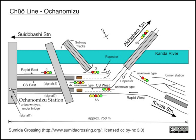
The two lines come together at Ochanomizu station, on the banks of the Kanda river. The waterway is wholly artificial, and relatively narrow here, although it is a real river. It was re-routed in the 1600’s (the Edo period) to form part of the outer defensive moat for an expanded Edo Castle (I’m fairly sure this portion wasn’t used for that, only a section further west). Today the banks are mostly concrete, although stone block is used in places, and it has the regular structure of a man-made waterway. Buildings crowd right up to the edge in places, although the north side has a large road paralleling it and the south side has the tracks and generally a road behind them. There is a surprising amount of greenery, helped in part by the steep embankments (street level is considerably higher than the water in places).
At Ochanomizu the tracks come together and the ground rises, putting street level above the tracks rather than below, so that roads crossing the river run above them. The tracks are running slightly to the northwest here.
The station includes two towers at the east end, likely for the station master and control over routing of trains in older times when mechanical switches and signals were in use. At least one is presently in use, as I’ve seen nighttime photos showing the interior lights on. At the station, the Rapid line tracks are on the outside, with the two Chūō-Sōbu tracks in the center (both lines stop here; it’s a major station).
Underground nearby is the Tōkyō Metro Marunouchi subway line station (also named Ochanomizu), one of the city’s few standard-gauge third-rail lines. It crosses the river on a low bridge and passes under the east end of the commuter station. Also underground nearby is Shin-Ochanomizu station, serving Tōkyō Metro’s Chiyoda line.
As an aside, the name Ochanomizu seems to translate as “water for tea”. I don’t know if that’s an historical reference to the river, or simply a coincidence (Japanese is a fairly complex language, particularly in its written form, and I don’t speak or read it so I have to use online translators, which aren’t good at reflecting the subtleties of the language).
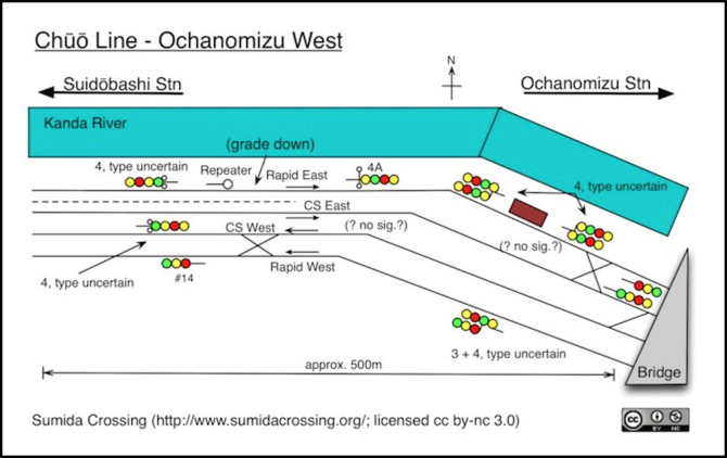
West of Ochanomizu
Just west of the station is one of the most interesting sections of the line. The tracks continue to the north-west for a while, even curving a bit more in that direction, before turning to the west, and then angling slightly to the northwest again (not shown in my diagram). This is the location of the complex series of crossovers that ultimately put the Rapid line tracks on the south side, and the Chūō-Sōbu tracks on the north side, against the river. The stations west of here only serve the Chūō-Sōbu tracks until you get to Yotsuya several kilometers to the west, beyond the end of the waterway. The land here remains above track level, and a row of moderately tall buildings plus a steep vegetated embankment separate them from the nearest road, making the tracks oddly isolated in the middle of the city. For modeling, Kato’s newer towers would work well here, although we’d be looking at their backs, which aren’t all that interesting.

As these are crossovers rather than diamond crossings, a train can end up moving from pretty much any track to any other track in either direction. It’s not complete: a Chūō-Sōbu westbound can’t reach the eastbound Chūō Rapid tracks, for example. But a train departing Tōkyō station going west can get to any track from any track except that it can’t switch from the westbound track to the Rapid eastbound line. And trains arriving on any track from the west can reach the eastbound Chūō-Sōbu track or the eastbound Rapid track. Finally, westbound Chūō-Sōbu trains can also access either westbound track. And those are probably the routings that matter operationally.
In the diagram the bridge at the right marks the end of Ochanomizu station. Here the Rapid line hasn’t yet fully separated to the south, so we have both westbound tracks south, and both eastbound tracks north. There’s a duck-under and another double-crossing just west of the portion shown here that together complete the shifting of the tracks.
If I model nothing else, I’m definitely modeling this half-kilometer, and hopefully with enough space so that typical 6 and 10-car trains won’t fill it. That means it needs to be more than two meters in length. If I include either station, I’m probably looking at five meters (15 feet) of track, although I could wrap that along two walls or around a peninsula. And I’d still like to include a portion further west, with the Sakura trees and the depot. Space may, however, preclude that in favor of other scenes.
Suidōbashi Station
At Suidōbashi station the tracks are running very slightly to the northwest. From the station going west the tracks are elevated (ground level has dropped closer to the water) and there is a row of buildings between the tracks and the waterway. Above the water, the inner Circular Highway runs on pilings, coming from the south (where it also runs above a small concrete-walled river) and turning north just before Iidabashi Station.
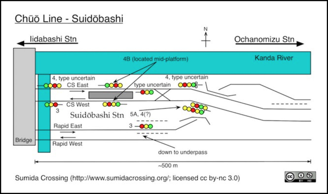
Although the multi-layer portion at the western end of this is interesting, with water, local roads, railway and highway stacked four deep, the area around the station itself does not call out to be modeled, and will likely be skipped over no matter how much space I have. One nice detail, however, is a small Shinto Shrine just behind the station at the east end.
Iidamacho and Iidabashi Station
The track goes west from Suidōbashi station, crossing the waterway with two bridges flanking it below and the highway passing overhead, before running along an elevated embankment with stone facing. Despite there being a row of buildings between the railway and the river, this is potentially very interesting to model, although somewhat challenging.
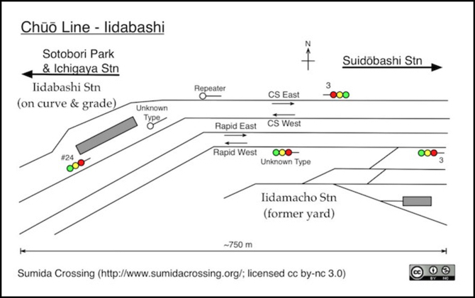
The embankment is the site of the former Iidamacho Freight Station. At one time this was a large freight classification yard serving the western heart of the city, but in later years it was reduced to a single customer, a newspaper taking delivery of paper rolls in the signature blue WaMu boxcars. Even that eventually ended, and the former yard has been redeveloped. All that remains is a small depot of some sort, populated with a variety of what appears to be track maintenance equipment and one covered track, possibly a repair shop of some kind. Unfortunately the position above street level makes it difficult to find photos of the equipment (Streetview provides a few though).
Just west the tracks return to the riverside, and the highway branches off to the north, briefly freeing up views of the tracks over the water again. The curve here is very abrupt, reportedly (per Wikipedia) just 300 meters (1,000’) in radius which is very sharp by rail standards. The track also drops down to run below street level rather than above, just a few feet above the water.
Along the curve, the space to the northwest of the tracks is no longer river, as the Kanda has gone underground and turned to the north. There’s a small waterway, little more than a channel for rainfall, located in a park sunken below street level. It’s apparently lined with stone block for part of its route, and a concrete channel for other parts, from the photos I’ve seen.
And planted atop the descending curve is Iidabashi station, which has to be one of the more challenging places to put a railway station, and potentially very interesting to model as a result. The platforms actually have to be angled horizontally to compensate for the tilt of the trains on each side (c.f., a JR press release I’ll get to shortly).
According to Wikipedia it’s due to move slightly west in the near future, to more level ground below an existing station entrance and extending partway in front of Sotobori Park, which seems like it would be an unpopular move with the locals. Wikipedia’s source is a 2014 press release from JR East (PDF). The Japanese text (as translated by Google) clearly states “Curve Radius = 300m”, and that the station will move 200m to the west. Oddly the diagram has an arrow marked R=300m that seems to show that the platform is moving 300m to the west. I suspect it’s just badly drawn, but it does make this a bit ambiguous.
There are certainly sharper curves in use, particularly for passenger-only lines. BART, for example, allows 70 MPH operation over curves of 120m radius. Still, the combination of a tight curve and a level change is a challenging one, and coupling that with the limitations imposed by a passenger platform makes things even worse. I can see why they’d want to relocate.
Streetview (images as of April 2015) doesn’t show any construction yet, but there is some apparent clearing of vegetation between the Chūō-Sōbu tracks west of the road bridge (compared to what is visible in older photos), that may be preparation for platform foundations.
Underground, the station serves three lines of the Tōkyō Metro subway (Namboku, Tōzai, and Yūrakuchō) and the Toei Ōedo subway.
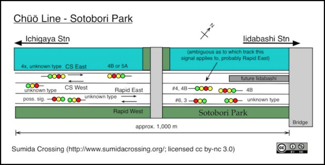
Sotobori Park
Just west of Iidabashi the tracks run fairly straight to the southwest, flanked on one side by water and on the other by the park, a long stretch of Sakura (Cherry) trees and a popular site for Hanami (flower viewing) parties when the trees are in bloom. The far bank is also lined with a narrow strip of Sakura trees, hiding the street from casual view, so the view from the park appears to be quite nice, even if the upper floors of buildings are clearly visible.
There’s no station for Sotobori Park itself, rather it fills a one-kilometer space between two of them: Iidabashi and Ichigaya. This is a linear park fit snugly between the railway tracks and a parallel road. It’s little more than a gentle embankment with trees, grass and a walking path. But because of the wide waterway it is a very open space, angled to catch the afternoon sun well into early evening. It’s probably a very nice place for a walk after work.
The name Sotobori is from the phrase “Soto Bori”, which means “outer moat”. And although the water looks like a continuation of the river, it’s not. This is the artificial portion of the former outer moat of Edo castle, or what remains of it. Most of the old moat was filled in with rubble from destroyed buildings after the Second World War, but this stretch alongside the park was preserved, although it is crossed by a couple of fills flanking roadways.
Unlike the flowing Kanda, which tends to a very dark green, the water here is stagnant, and colored brightly green by algae, at least on aerial photography. From ground level, the two do not appear to look too different in photographs.
The signals here are interesting. I thought at first that there weren’t any, but that’s simply because most photographers focus on the park itself or the fishing ponds adjacent to Ichigaya station. Looking more carefully, there are a surprising quantity of signals along this kilometer of track, given that there aren’t any crossings and the Rapid line has no stations closer than Yotsuya. More careful examination turned these up, but usually photographed from a considerable distance, often in the background and out of focus. Trying to specifically identify them, or even count lamps, was problematic. Only a few showed colors, and a couple were clearly distorted by camera-shake. Streetview was particularly bad, showing two reds on one signal due to a double exposure (no Japanese signal has two red lamps, and a clearer picture of the signal identified it as a normal one).
There appear to be block signals for the Rapid line on both tracks in both directions. But only the eastbound track appears to use signals optimized for higher speeds (type 4B in both directions) while the westbound clearly uses a simple three-head signal wrong-way on the westbound track (I can’t tell what type it uses for westbound trains on that track, only that there is a signal there of some kind). This may be because only the eastbound line have a very long clear run. The westbound line used in reverse has a switch at Iidamacho station, about a kilometer or so to the east, and both tracks have Yotsuya station around 1 to 1.5 km to the west.
The westbound 4B is a bit odd, since they use 3-lamp signals in most other places and I can’t see why this section would be special. In one streetview image the two seem to be reversed, with a 3 closer to the river and the four on the track next to the park. However that’s an inconclusive image (from the back side of the signal, and quite blurry) and one photo I found seems to show the arrangement above fairly clearly (perspective is always an issue though, as these are typically long telephoto shots that compress space).
Number plates were only visible on two eastbound Rapid line signals on the eastern section, but most of the other signals were not clear enough to be sure if they were missing.
Closer to Ichigaya there are a number of signals, including a mysterious one that’s very clearly wrong-way on the Chūō-Sōbu. It’s at least a four-lamp signal based on one fairly clear photo, but it can’t be a 4A due to the light positioning, so it’s one allowing higher-speed aspects (either 4B or 5A). It’s also the only wrong-way signal I’ve spotted on the Chūō-Sōbu away from the crossovers at Ochanomizu. Very odd.
It’s possible that this is the station exit signal for the relocated Iidabashi platforms, built in anticipation of their relocation. A 4B would make sense in that application.
The photo appearing on my website’s banner is of this stretch of the line, taken from the park.
Ichigaya
At the western end of the park is Ichigaya station, built right up against the water. In addition to the above-ground Chūō-Sōbu station, there is an underground portion serving the Tōkyō Metro’s Namboku, and Yūrakuchō lines and the Toei Shinjuku line. This actually extends under the river and along the opposite bank; it’s a rather extensive station complex, even if it looks small above ground.
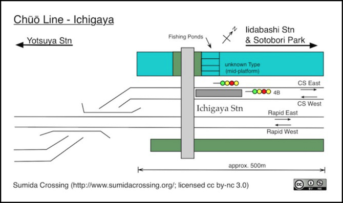
Immediately west of the station the Chūō-Sōbu tracks climb and cross over the Rapid line, and the water ends. There’s one final station, Yotsuya, which serves both lines and then the tracks duck into a tunnel and turn northwest to head to Shinjuku Station. While I’m tempted to model Ichigaya (portions of it look a lot like Kato’s Urban Transit Station), I do not expect to model anything to the west of it. And if I’m honest, there’s not all that much visual appeal here.
Just west of Yotsuya, where the tracks go underground, one track splits off and uses a single-track tunnel with a red-brick portal. It’s wide enough that it may have been a double-track tunnel back when trains were smaller. I presume this is from the original Kōbu Railway and the concrete-portaled tunnel of the other three tracks was a later addition. A nice detail, but not well placed to be part of the layout, unless I “selectively compress” it onto the end of a Sotobori Park scene.
In Summary
So that’s what I have. There’s far more there than I could possibly fit on a layout, even if I didn’t want to model other things. I like full-length trains, and that means my stations need to be quite large, so modeling four of them with space between just isn’t practical. I’m going to have to pare this down to my favorite bits as a couple of “scenes”, which is going to be painful, and I haven’t yet grappled with that.
Writing this down has helped to focus my thoughts (one reason why I did it). I know I want the portion west of Ochanomizu (and probably Ochanomizu also; it’s always been one of my favorite stations). And the stretch along Sotobori park is likely the second. Maybe I could do both as two sides of a peninsula, and fit either Iidabashi or Iidamacho in at the tip (not both, alas). I suspect Ichigaya, as much as I like it, won’t make the cut. But even that may be trying to fit too much. I need to be careful to avoid the temptation to cram in too much track this time around. I hope I’ve learned my lesson there.
Still more thought is needed before I make any decisions, and I also need to spend some more time fleshing out other potential scenes and how these will relate to those. I know one of them will be some kind of yard, although I’m not sure if I’d use Tabata or something else as the source. Tabata has the benefit of mixing Freight engine servicing and Shinkansen storage with the commuter train storage. Although I may violate prototype enough to allow me to store my Chūō and Sōbu trains in the same yard, as I doubt I can afford space for two different yards. I’d also like to model some part of the western track north of Shinjuku, where the Yamanote parallels the Yamanote Freight Line (which carries a wide variety of passenger trains in addition to freight).
And if I had enough space, although I doubt I will, I’d like to include a portion of the port area, with its freight terminals and the small remaining yards.